
A land surveyor’s angle on development and construction
The plethora of different skills and professions this sector requires is wide indeed. Perhaps one of the more technical and lesser known professions is that of the Surveyor.
Essentially originating as a ‘mapmaker’, the profession started out as a means of plotting land boundaries; of designing the lie of the land. Today this profession has developed. While these ancient basics have remained part of the job description, Surveyors today use specialised tools and equipment to collect data and create precise representations of the land and property boundaries.
Surveyors may work for private firms, government agencies, or as independent consultants. They are also involved in many types of projects, including construction projects, real estate transactions, land development, and environmental assessments.
Design & Build caught up with Alan Micallef who spoke to us at length on the services provided by his company.
“We survey buildings, all types of properties, land and structures,” said Mr Micallef, clarifying that surveying a building ranges from the creation of ‘as built’ plans of a property to the structural sanity of the development. The ‘as built’ plans reproduce the building and are normally used by architects not only for restructuring but to also be attached to applications for planning.
surveying is required to ensure that the land is fairly divided. These results are then used, most often in the sale of property and find themselves attached to contracts
Perhaps surprisingly enough, surveying is also required when a demolition is in progress. Mr Micallef explained that while the architect is in charge of the project, surveyors provide raw material for the architect to work upon. In particular, the architect relies heavily on the measurement and layout of the development. “And the architect relies on our data to design and build the project,” pointed out Mr Micallef.
A profession of data capture
Another function of surveying is the mapping out of land. Given that Maltese inheritance laws provide for a lot of subdivision on land, Mr Micallef explained that surveying is required to ensure that the land is fairly divided.

These results are then used, most often in the sale of property and find themselves attached to contracts. “We are also involved in marking out levels for projects as well as in indicating the proposed location of landmarks and objects,” explained Mr Micallef. Marking out levels is crucial to the project so that when foundations need to be laid, depths are accurate. In this same procedure, the street alignment is also taken into account since without this, a house may impinge upon the street notwithstanding its having been properly planned: clearly a no-go.
street alignment is also taken into account since without this, a house may impinge upon the street notwithstanding its having been properly planned
He pointed out that on building sites, among all the rubble, one can always notice markings. This, he explained, gives levels and alignments. On site, the surveyor also marks out particular structures in preparation for the actual building contractor. The Surveyor interprets the architect’s plans and marks out walls and load-bearing pillars so that the builder will have a head start. “This procedure is carried out at all sorts of developments, be they commercial or residential,” observed Mr Micallef.
From GPS to Drones – technology helps
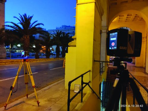
All this, said Mr Micallef, relies on technology which is in constant evolution. “The most basic equipment which one associates with the land surveyor is the total station,” smiled Mr Micallef. He explained that a total station is a surveying instrument that captures electronic distance and angular measurements to provide both position and height measurements over a land survey.
They are used with precision to derive spatial information to locate objects and features. Mr Micallef said that the total station allows surveyors to create a map of a spot in three instead of two dimensions, as was generally the case with the surveying instruments of the past.
He added that a total station has high accuracy and range due to its lenses, adjustable vertical laser levels, and bubble axes. While this vital piece of equipment is perhaps the one used most or is most frequently associated with surveying, Mr Micallef also uses other instruments including “…GPS, laser scanners, drones and on a few occasions when we do underwater surveying, echosounders.” All these enable him to take accurate data, particularly where accessibility is an issue.

Given that his outfit is professional and much in demand, Mr Micallef said that most of the equipment belongs to his company and it is only that equipment which is rarely used that he leases from his reputable and reliable sources.
Drones, he explained, are a great help in measurement. “We use drones to measure out land, and facades. Basically the technique used to measure out facades using the drone is called photogrammetry but we still incorporate additional information and knowledge through the joint utilisation of GPS receivers, total stations, and lidar” observed Mr Micallef.
Solid reputation
“We use drones to measure out land, and facades … but we still incorporate additional information and knowledge through the joint utilisation of GPS receivers and total stations”
Mr Micallef’s professionalism and expertise in the field of surveying is well-known. A veteran of 25 years in the field, Mr Micallef had started out as an employee in another company. “in 2014, the company I was employed with folded up and it was either shift to another company or strike out on my own,” said Mr Micallef. The rest is history.

for which Alan Micallef Surveying Services was contracted, involving plans, facades and other such technical work.
Whilst the profession of surveying is not one in which one can easily operate reliably as a single individual, Mr Micallef ensures that his team shares or adapts to his vision of excellence.
He hence relies on a team of seven collaborators who are involved in the various parts of the land surveying process. “I try to involve the team in both office and field work; that a person is involved both in the work on the field and in the follow-up work involved in the office,” explained Mr Micallef. This may not always be possible but it is an operational basis which he strives to implement as much as possible.
A large portfolio of projects
As the lead surveyor and owner of the organisation, much of the work which Mr Micallef does these days is client relations related: meeting with clients and outlining their needs. He then evaluates the assignment’s objectives, and instructs and discusses with the team on how best to service the project.
the work undertaken in various historical buildings regarding their restoration involved plans, facades and other such technical work. Such plans assist the client in pre-quantifiying their restoration costs
Projects for Mr Micallef are many and varied. From The Quad to Tigné Point Development, Alan Micallef Surveying Services have been a regular contractee for various parts of sprawling and architecturally important developments., and Mr Micallef looks with satisfaction at his organisation’s contributions to these major developments.
Mr Micallef said that the work undertaken in various historical buildings regarding their restoration involved plans, facades and other such technical work. Such plans assist the client in pre-quantifiying their restoration costs.
Different projects different challenges
Mr Micallef looks on projects as different challenges. Some, he explained are small; residential homes are one such example. Others are historic: “planning out a palace for restoration and rehabilitation, for example requires a fair deal of complex planning,”, he explained. Then there are the mega complexes which are not only intricate in themselves but also require meticulous planning to ensure that the best and most accurate equipment is used through the most efficient methods, and to their strongest means.

Maintenance of the equipment has to be factored in. Mr Micallef explained that their equipment: largely of well-known brands such as Leica and Faro, is calibrated by being regularly sent to the manufacturer or an approved servicing company. This, too, is why Alan Micallef Surveying Services has invested in having sufficient superfluous equipment to ensure that business will keep steadily flowing for its clients whilst maintaining their standards of excellence.
Optimism for the future
Alan Micallef looks to the future with confidence and optimism. Firmly established in his field, his goals are to maintain his organisation’s high professional reputation and standards on efficiency and precision.
“the best and most accurate equipment is used through the most efficient methods”
With Alan working with his wife Stephania, Alan Micallef Surveying Services can rely on the integrity of a family business with the added benefits of a professional, international team.
Comment